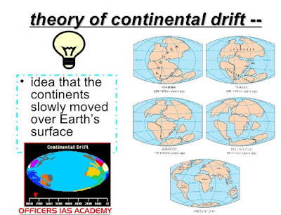
· According to Alfred Wegener, the entire landmass of the globe was
together about 280 million years ago.
· It was termed as Pangea, a super continent.
· The huge water body surrounding the Pangea was known as Panthalasa.
· From 280 to 150 million years ago, Pangea was broken latitudinally
into northern and southern parts known as Laurasia (Angaraland) and
Gondwanaland, respectively.
· Both of them drifted away and in between a shallow sea emerged by
filling up the water from Panthalasa. It was known as Tethys sea.
· Later on Laurasia and Gondwanaland rifted and finally drifted to
form the present day distribution of land and water on the earth.
Evidences of Drift :
· Wegener gave a number of evidences in support of the unification
of landmass in geologic past.
· They are such which cannot be negated even today.
· Eastern coast of South America is identical to Western coast of
Africa which fits to a certain depth in the ocean.
· To a certain extent coastal areas and continental shelves have
been modified by oceanic waves through denudation.
b. Geological similarities:-
· The mountain systems of Southern Atalantic coast in South America
and Africa show the similarity of the extension in both continents.
· The distribution of coal and vegetation over South America,
Africa, India and Australia proves that they were together in geological past.
· The classical glacial deposits during carboniferous period over
these landmasses resemble each other which tells the story of togetherness.
· Today they lie in different climatic zones. Apart from above
evidences put forward by Wegener, other evidences (known later) are also there
which support the idea of continental drift.
d. Evidences from paleomagnetism :–
· Paleomagnetism is the study of the direction of pole through ages.
· Magnetically susceptible minerals like haematite, pyrhotite
magnetite etc. get aligned with the
magnetic pole of the earth and recorded in the solidification of magma during
that time.
· It is found that periodic changes have occurred and poles have
wandered which is not possible for the entire earth.
· Hence, it is the twist and turn of the landblock and not for the
entire earth which has again explained that the continents have shifted their
positions.
· Along the mid Atlantic ridge, magma comes out at the sea bed and
gets solidified.
· A new zone is formed and this process is continuing since millions
of years.
· It is leading for diversion of continental block, and hence the
size of the Atlantic ocean is increasing which is termed as sea floor
spreading.
· It is the classical example of the shifting of continents.
· The explanation of continental drift through sea floor spreading
and the study of paleomagnetism is commonly known as Plate Tectonics.


No comments:
Post a Comment